Hakone Old Tokaido Road Hike: Times, Bus and Teahouse
Most people who walk the Old Tokaido road in Hakone don't walk all of it. The whole climb from Hakone-Yumoto to the lake is 11.6 km, 4 hours 25 minutes and 684.8 m of height difference on Kanagawa Prefecture's course sheet. The part worth your day is shorter: the mossy stone paving between Hatajuku, the Amazake-chaya teahouse and Moto-Hakone on Lake Ashi. A bus runs beside the road, so you can pick how much of the slope you want.
One thing changed this year and older write-ups still have it wrong. Since 1 April 2026 the K line bus no longer ends at Moto-Hakone-ko. It goes on past Hakone Shrine to Yama no Hotel, there are only 11 buses a day up the hill, and on the busiest days it stops short at the teahouse.
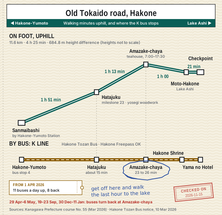
How long does each part take?
Kanagawa Prefecture prints section times for the full course, from the Sanmaibashi bus stop beside Hakone-Yumoto Station to the Hakone Checkpoint. Grouped by the places where you can join or leave by bus:
| Section (walking uphill) | Time | What it is |
|---|---|---|
| Sanmaibashi → Hatajuku | 1 h 51 min | Mostly along the road, past Shoganji and Saunji temples |
| Hatajuku → rest house beside Amazake-chaya | 1 h 13 min | The steep part, with long runs of stone paving |
| Rest house → Moto-Hakone | 1 h 00 | Stone paving through forest, then down to the lake |
| Moto-Hakone → Hakone Checkpoint | 21 min | The cedar avenue along the shore |
| Whole course | 4 h 25 min | 11.6 km |
Three ways to cut it:
| Plan | Walk | Time on foot | For whom |
|---|---|---|---|
| A. Teahouse to the lake | Amazake-chaya → Moto-Hakone | about 1 hour | Anyone on a one-day Hakone loop |
| B. Hatajuku to the lake | Hatajuku → Amazake-chaya → Moto-Hakone | 2 h 13 min | You want the real climb and the best paving |
| C. All of it | Sanmaibashi → Checkpoint | 4 h 25 min | Hikers with a full day and nothing else planned |
I'd take plan A on a day trip and plan B if you're staying a night. Plan C spends almost two hours on the lower road before the old paving starts in earnest, and that's time I'd rather give to the lake.
Two notes on the numbers:
- The one-hour figure is the cautious one. The Ministry of the Environment's national park course gives 35 minutes and 1.8 km between Hakone Shrine and Amazake-chaya, plus 10 minutes (0.7 km) from the shrine to the Moto-Hakone-ko pier. The prefecture gives 60 minutes from the rest house to Moto-Hakone. Plan on the hour; if you arrive early, the shrine is right there.
- Nobody publishes downhill times. Both sources time the walk in one direction only, so I don't quote a figure for coming down from the lake. On wet stone, downhill is the slower and riskier way.
How do I get to the start by bus?
The bus is the Hakone Tozan Bus K line (Hakone Kyukaido Line). At Hakone-Yumoto Station it leaves from bus stop 4.
| From Hakone-Yumoto, stop 4 | Ride | What's at the stop |
|---|---|---|
| Hatajuku | about 15 min | 23rd milestone, woodwork hall |
| Amazake-chaya | 23 to 26 min | The teahouse, right outside |
| Hakone Shrine → Yama no Hotel | end of the line | Lake Ashi |
Hakone Navi gives the ride to Amazake-chaya as "about 23 minutes" on one page and "about 26" on another, so both are in the table.
What changed on 1 April 2026 (Hakone Tozan Bus notice of 10 March 2026):
- The lake terminal moved from Moto-Hakone-ko to Yama no Hotel, by way of Hakone Shrine.
- 11 buses a day run from Hakone-Yumoto to Yama no Hotel and 8 a day come back, the same on weekdays and weekends.
- One bus is the exception: the 16:40 from Hakone-Yumoto still ends at Moto-Hakone-ko and doesn't go to Hakone Shrine or Yama no Hotel.
- On the days when the lakeside roads jam, the bus only shuttles between Hakone-Yumoto and Amazake-chaya. For this year those days are 29 April to 6 May, 19 to 23 September, and 30 December 2026 to 11 January 2027.
How I read that. Eleven buses in a day is roughly one an hour, so look up the departure before you leave your hotel; this isn't a line where you just turn up. And with only eight buses back down, don't count on the K line for the return. Walk to the lake and go back on the H line from Moto-Hakone-ko, the main bus line between the lake and Hakone-Yumoto (about 40 minutes and ¥1,210 to Hakone-Yumoto, or free with the Freepass; details in the Hakone bus guide).
The New Year dates matter if you're coming this winter. From 30 December to 11 January the bus turns round at the teahouse, which is exactly where plan A starts, so the walk still works. You just can't ride the K line on to the shrine.
Tickets. The K line is a Hakone Tozan Bus, so the Hakone Freepass covers it; Odakyu lists the Old Tokaido buses among the Freepass services. Without a pass, pay by Suica, PASMO or cash as on other Hakone buses. I couldn't read the K line fare table or its timetable on the official site (the pages are drawn by script and came up empty), so there are no K line fares or departure times on this page. Use the official timetable search linked at the bottom.
What is Amazake-chaya, and what does it cost?
A thatched teahouse on the old road, run by the same family since the Edo period. The shop says the current owner is the 13th generation. Japan Tourism Agency's notes add that four teahouses once stood here, this is the one left, and the building was rebuilt in 2009 with old materials.
| Hours | 7:00–17:30, last order 17:00 |
| Closed | Never. Open every day of the year |
| Amazake (one cup) | ¥500 |
| Chikara-mochi (2 rice cakes) | ¥600 |
| Miso oden (5 pieces) | ¥500 |
| Tokoroten (eat-in only) | ¥600 |
| Iced matcha / shiso juice | ¥500 each |
| Bus stop | "Amazake-chaya", right outside |
Amazake here is the non-alcoholic kind, a warm sweet drink made from rice. A cup and a plate of mochi come to ¥1,100. Hakone Navi's listing still shows ¥400 for the amazake; the shop's own site says ¥500, and that's the one to trust.
A date for the diary: every 14 December the shop holds its Yogoro festival and pours amazake free from 7:00 to 10:00 (¥400 after that, the shop says).
The old road rest house, the point the prefecture uses for its section times, stands beside it. The stone path to the lake starts behind the teahouse.
What is there to see at Hatajuku?
Hatajuku was the resting village halfway up the eastern slope. Two things are within a few minutes of the bus stop:
- The 23rd milestone (ichirizuka). Milestone mounds stood every ri (about 4 km) from Nihonbashi in Edo. Hakone had three; this one, the 23rd, was fully restored in 1998. It's right by the stop, and the stone paving climbs into the forest from it.
- Hatajuku Yosegi Kaikan. The village is the home of yosegi-zaiku, the patterned wood marquetry sold all over Hakone. The hall is free, open 9:30–16:30, closed Mondays and over New Year, 3 minutes from the stop. Making a coaster costs ¥1,200.
How hard is it, and what should I wear?
The paving dates from 1680, when the shogunate laid stone over the pass. Before that, the prefecture's sheet says, the road was laid with bamboo, which rotted. The stones are rounded, uneven and mossy. That's the charm, and also the problem.
What the prefecture asks walkers to do:
- Wear sturdy shoes. The stone sections are hard to walk on in places.
- Plan to be off the trail before sunset.
- Carry rain gear and water. Mountain weather changes fast.
- Take your rubbish home.
My own rule from those figures: start plan B from Hatajuku by early afternoon at the latest in winter. Two and a quarter hours of walking plus a stop at the teahouse puts you on the stones after dark if you leave at 14:30 in December. Plan A fits almost anywhere in the day.
After rain, think again about plan B. Odakyu's own write-up of the walk warns that the stones are slick when wet and tells people who aren't happy on rough ground to take the bus.
How does it fit into a Hakone day?
- With the classic loop. Do the loop the usual way (train, cable car, ropeway, pirate ship) and get off the boat at Moto-Hakone. That leaves you at the wrong end for plan A, walking uphill to the teahouse with only eight K buses a day to bring you down. It's easier in reverse: K bus from Hakone-Yumoto to Amazake-chaya in the morning, walk down to the lake, then Hakone Shrine, and take the boat and ropeway back. The Hakone day trip itinerary has the loop times.
- With the Checkpoint. From Moto-Hakone the cedar avenue runs about 500 m to Onshi-Hakone Park, with about 400 cedars. Add the 21 minutes to the Hakone Checkpoint (adults ¥500) and you've walked the road the way Edo travellers met it: slope, teahouse, lake, barrier.
- With a pass. Every bus and boat above is on the Freepass. Check whether it pays for your day in the Hakone Freepass calculator.
Guided walks on the old road
- Hakone Old Tokaido hiking tours on Viator a guide for the stone road and the teahouse stop
- Hakone Freepass on Klook covers the K bus, the boat and the ropeway
PR Affiliate links (disclosure): booking through them supports this site at no extra cost. Prices on partner sites may differ from the official prices on this page.
Frequently asked questions
Does the K bus still go to Moto-Hakone-ko?
Only one a day. Since 1 April 2026 the line ends at Yama no Hotel, past Hakone Shrine. The 16:40 from Hakone-Yumoto is the single bus that still ends at Moto-Hakone-ko.
Can I do the walk in winter?
Yes, the teahouse is open every day and the bus runs. From 30 December 2026 to 11 January 2027 the K line only goes as far as Amazake-chaya, which is where the one-hour walk starts. Wear shoes with grip and keep to the short plan on short days.
Is the Old Tokaido walk free?
The road, the milestone, the rest house and the Yosegi Kaikan cost nothing. You pay for the bus (covered by the Freepass), whatever you order at the teahouse, and ¥500 if you go into the Checkpoint.
Which direction is better?
Uphill from Hakone-Yumoto's side, ending at the lake. The bus is more frequent from Yumoto (11 a day against 8), the official times are written for that direction, and you finish next to the shrine, the boats and the H line bus stop.
Where do I get the bus at Hakone-Yumoto?
Bus stop 4, signed for the K line towards Kami-Hatajuku and Yama no Hotel via the old road and Amazake-chaya.
Official sources (checked 2026-11-15)
- Course sheet No. 55, Old Hakone Road stone-paved course: distance, section times, height difference, cedar avenue, cautions (Kanagawa Prefecture, March 2026)
- K line terminal moved to Yama no Hotel: trips per day, the 16:40 bus, dates the bus turns back (Hakone Tozan Bus, 10 March 2026)
- Hakone-Yumoto bus stops and the timetable search (Hakone Navi)
- Hatajuku area: bus minutes to Hatajuku and Amazake-chaya (Hakone Navi)
- Menu, prices, hours and the 14 December festival (Amazake-chaya)
- Walking time and distance between Hakone Shrine and Amazake-chaya (Ministry of the Environment)
- The 23rd milestone at Hatajuku (Hakone Navi)
- Yosegi Kaikan hours and workshop price (Hakone Navi)
- History of the pass, the teahouses and the 1680 paving (Japan Tourism Agency)
- Old Tokaido itinerary and Freepass coverage of the K line (Odakyu Electric Railway)
- Route description of the old road (Hakone DMO)
More for your trip
- Hakone Freepass calculator: single tickets vs the pass for your Hakone rides
- Enoshima & Kamakura calculator: single tickets vs Noriorikun vs Freepass
- Japan tax-free refund calculator: the new system from 1 Nov 2026
- Yokohama day trip cost calculator: single tickets vs the Minatomirai, JR and Tokyu passes
- Mt. Takao day trip cost calculator: single tickets vs the Mt. Takao Ticket
- Kawagoe day trip cost calculator: Koedo Kawagoe Coupon vs single tickets and the Premium pass
- Mt. Oyama day trip cost calculator: Tanzawa-Oyama Freepass A vs B vs single tickets
- Odawara day trip cost calculator: Odakyu vs Romancecar vs JR vs Shinkansen, plus Odawara Castle tickets
- Misaki Maguro Kippu calculator: does the Keikyu tuna ticket pay off for your trip
- Hayama Excursion Ticket calculator: Keikyu's Hayama Joshi-tabi Kippu: 2026 prices, the break-even point and the ¥1,000 cruise add-on
- Kamakura temple entrance fees calculator: Great Buddha, Hasedera, Hokokuji, Engakuji and Kenchoji for your group
- Enoshima island tickets calculator: escar, Sea Candle, Iwaya Caves and aquarium: single tickets vs the 1day and Area Passport
- Yokohama Cosmo World tickets calculator: ride prices and the cheapest discount ticket for your group
- Yokohama Anpanman Children's Museum tickets calculator: price by date, family total, sale date and cancellation fee
- Hako Ticket calculator: unlimited entry to 20 Hakone hot springs and museums: does it pay off for your plan
- Hakone Yunessun tickets calculator: price by date, Passport vs Mori no Yu, rentals and tattoo rules
- Hakone museums tickets calculator: Pola, Okada, Open-Air, Glass Forest and more: Freepass discounts and your group total
- Sagamiko Illumillion tickets calculator: winter lights: price by date, night free pass and the JR + bus route from Shinjuku
- Hakone Kamakura Pass calculator: one 3-day pass for both areas vs two Freepasses vs single tickets
- Sarushima Island ferry calculator: ferry and admission by fare day, timetable and the train from Tokyo
- Yokosuka Naval Port Tour calculator: cruise price by fare day, booking and whether the Mankitsu Kippu pays
- Hakone day trip from Tokyo: cost and route: three budgets and the loop in order
- Hakone Freepass: the break-even math
- Kamakura and Enoshima day trip: cost: which pass to buy
- Kamakura day trip itinerary: one-day route with Enoshima, closing times and cost
- Hakone or Kamakura? Day trip compared: cost, time, closing times and a 3-question chart
- Hakone to Kamakura by train: Hakone-Yumoto to Odawara, JR to Ofuna, Yokosuka Line to Kamakura: minutes from the official timetables and which pass covers which leg
- Yokohama to Hakone by train: Tokaido Line or the Shinkansen from Shin-Yokohama to Odawara, the Tozan Train to Hakone-Yumoto, the Freepass sold at Odawara, and why the Yokohama bus no longer reaches Hakone
- Yokohama day trip with kids: family train cost: child fares and the cheapest ticket for a family
- Yokohama Red Brick Christmas Market 2026: dates, hours, the 9 special days at ¥1,000 and the 27 at ¥500, and who gets in free
- Ice skating at Yokohama Red Brick Warehouse (Art Rink 2026–27): 28 Nov – 14 Feb, ¥2,000 adults then ¥1,700 from 4 January, hours for every part of the season and the glove rule
- Yokohama illuminations 2026–27: dates, Yorunoyo show times, fireworks nights and a one-evening route
- Yomiuriland Jewellumination 2026–27: 29 Oct – 4 Apr, lights 16:00–20:30, ¥1,800 admission vs the ¥3,100 After Pass, the ¥300 gondola and the Keio passport
- Narita Airport to Yokohama: Narita Express or the YCAT bus, every direct departure, and the ¥5,200 round-trip ticket
- Haneda Airport to Kamakura: ¥840 with one change at Yokohama, and the direct bus that is suspended
- Narita Airport to Kamakura: Narita Express to Ofuna, or the direct rapid train with no change, departure by departure
- Haneda Airport to Enoshima: ¥1,100 by Keikyu, JR and the Enoden, the Ofuna and Fujisawa finishes, and the airport bus that is suspended
- Narita Airport to Enoshima: Narita Express to Ofuna and the Shonan Monorail (¥5,150), and why the ¥5,200 round-trip ticket makes the return ¥5,880
- Narita Airport to Hakone: Narita Express to Shinjuku and the Romancecar (¥5,800), or Shinagawa and the Shinkansen, with the round-trip ticket and Freepass sums
- Yokohama day trip itinerary: one-day route, opening hours and cost
- Hakone day trip itinerary: the one-day loop in order, ride times and the last boat
- Mt. Takao day trip itinerary: which trail, official hiking times and the last cable car
- Mt. Oyama day trip itinerary: four legs from Shinjuku, the last cable car, three plans and the 2026 autumn light-up
- Mt. Takao cable car vs chair lift: same ¥490 fare, hours by month, the ¥1,450 Mt. Takao Ticket and which ride to take
- Mt. Takao autumn leaves festival 2026: 24 Oct – 13 Dec, peak mid-Nov to early Dec, the Fri–Sun light-up along the cable car line and the ¥1,450 trip from Shinjuku
- Tokyo to Mt. Takao by train: Keio from Shinjuku or Shibuya for ¥430, the JR Chuo Line change at Takao, the Mt.TAKAO train times and the Mt. Takao Ticket price from every station
- Mt. Takao onsen: ¥1,100 weekday bath next to Takaosanguchi Station, hours, the strict tattoo rule and the ¥3,480 weekday Yuttari Kippu
- Hakone Romancecar tickets: price, how to book, observation seats and luggage
- Hakone day-use onsen: prices, hours and tattoo rules for a hot spring on a day trip
- Hakone luggage: storage and hotel delivery: drop times, prices and lockers for a suitcase in Hakone
- Kawagoe day trip itinerary: one-day route in loop-bus order, bus times, opening hours and cost
- Kawagoe Castle Honmaru Goten tickets: ¥100 entry, when the ¥370 and ¥600 combination tickets pay, and every closed date to March 2027 including the eight-day New Year closure
- Kitain Temple, Kawagoe: ¥400 entrance fee, hours that shorten on 24 November, closed dates and the walk from three stations
- Hakone pirate ship tickets: Lake Ashi cruise prices, which ticket is cheapest and the timetable
- Hakone Open-Air Museum tickets: counter vs online vs Freepass price, hours and access
- Hakone Shrine: hours, access and fees: bus or pirate ship to Moto-Hakone-ko, Treasure Hall and goshuin prices, Kuzuryu Shrine and Hakone Motomiya
- Hakone Checkpoint (Sekisho) tickets: ¥500 entry, ¥400 with the Freepass, hours and the 5-minute walk from the pirate ship pier
- Hakone Gora Park tickets: ¥650 or free with the Freepass, hours, the cheaper cable car stop and Craft House prices
- Hakone Ropeway tickets and Owakudani: flat fare, hours, which pass, black eggs and the guided nature trail
- Cup Noodles Museum Yokohama tickets: admission, make your own cup noodle, Chicken Ramen Factory booking and hours
- Hakone Tozan Railway tickets: fares for every station, the 1-day pass, IC cards and last trains
- Enoshima Aquarium tickets calculator: price, pass discounts, the Odakyu set ticket from Shinjuku and dolphin show times
- Hakkeijima Sea Paradise tickets: aquarium and ride passes, which one to buy and the cheap Keikyu ticket from Tokyo
- Yokohama Air Cabin tickets: ropeway prices, the Ferris wheel set ticket, hours and closing days
- Yokohama Sea Bass ferry: water bus fares between the four piers, which boats skip Red Brick, and boat vs train
- Yokohama bay cruise prices: ¥2,000 harbour loop, ¥3,000 night cruise, factory night cruise and Marine Rouge dinner: times, piers, child fares and booking rules
- Sankeien Garden tickets: entrance fee, hours, every bus route and the Minato Burari discount
- Minato Burari Ticket (Yokohama bus and subway day pass): ¥700 or ¥750 Wide, what it covers and what it does not, every single fare, the Akai Kutsu loop and four day plans with the math
- Akai Kutsu loop bus (Yokohama): ¥220 a ride from Sakuragicho bay 3, all 18 stops in order, minutes to Chinatown and Harbour View Park, and the last bus back from each stop
- Enoden 1-day pass (Noriorikun): price, every Enoden fare, where to buy and six day plans with the math
- Yokohama Marine Tower tickets: day and night prices, the 1-day pass, closing days and the Landmark Sky Garden closure
- Manyo Club Yokohama (Minatomirai hot spring): ¥3,500 admission, the ¥2,500 late-night fee after 3:00, what the set includes and the no-tattoo rule
- Hikawa Maru tickets (Yokohama museum ship): ¥300 cash only, hours, closed days to March 2027 and what is on each deck
- Hara Model Railway Museum tickets (Yokohama): ¥1,500 every day, timed-entry tickets sold on e+ and at FamilyMart rather than at the desk, the 16:00 last sale and the Thomas runs from 17 December
- THE MOVEUM YOKOHAMA tickets (Monet and Ukiyo-e): ¥3,000 online or ¥3,800 at the door, the ¥5,600 Pair ticket, kids free, the 45-minute show on the hour, no cash and the shuttle from Yamashita Pier
- Yokohama Museum of Art tickets: ¥500 collection exhibition, free Saturdays for teens, galleries shut 24 Nov–10 Dec and 29 Dec–3 Jan, every open day to 11 February 2027 and the free Grand Gallery
- Mitsubishi Minatomirai Industrial Museum: ¥500 cash, weekday last entry 14:30 (not 16:30), closed Tuesdays and Wednesdays, every closed date to 6 January 2027 and the Shinkai 6500 mock-up
- Nippon Maru and Yokohama Port Museum tickets: ¥800 combo or ¥400 ship only, students ¥100 on Saturdays, and the days the ship is shut to March 2027
- Yamate Western Houses (Yokohama, free): seven free houses on the Bluff, the Christmas 2026 country in each, closed Wednesdays by house to March 2027 and the walk from Ishikawacho
- Enoura Observatory tickets (Odawara): ¥3,300 booked ahead, ages 12 and over, every free shuttle time from Nebukawa Station and four trains from Tokyo from ¥1,120
- Nihon Minka-en tickets (Japan Open-Air Folk House Museum, Kawasaki): ¥550 at the gate, kids free, closed days to March 2027 and the 21, 22 and 28 November night opening
- Lalique Museum Hakone tickets: ¥1,500 at the door, ¥1,200 in advance, the ¥2,750 Orient Express tea you cannot book, hours and the January closing days
- Okada Museum of Art tickets (Hakone): ¥2,800 at the door, ¥2,550 bought at Hakone-Yumoto Station, foot bath included and the no-phones rule
- Hakone-en Aquarium tickets (Lake Ashi): ¥1,600 adults, ¥800 kids, seal feeding and diver show times, and the bus a Freepass covers
- Mt. Takao Monkey Park tickets: ¥600 since September 2026, not ¥500; hours, last entry and why the lift is no use after closing
- Takao Trick Art Museum (closing 30 November 2026): the 12 open days left, ¥1,650 since July 2026, the ¥200 printed coupon and why to visit after the mountain, not before
- Takaosan Yakuoin temple (Mt. Takao): goma fire ritual at 9:30, 11:00, 12:30, 14:00 and 15:30, ¥500 temple seal, shojin ryori lunch from ¥3,300 booked two days ahead, and New Year
- Kawasaki Daishi temple: ¥280 from Shinagawa or ¥330 from Haneda Airport, fire ritual times, hall hours, New Year 2027 and the 900th-anniversary festival in May 2027
- Nogeyama Zoo, Yokohama (free): shuts for rebuilding on 7 January 2027: every open day until then, the animals still there, keeper talk times and the walk from Sakuragicho
- Suzuhiro Kamaboko Museum (Odawara): ¥1,980 kamaboko-making class, not ¥1,500; every start time, when your kamaboko is ready, web booking from 130 days ahead and the ¥220 stop on the way to Hakone
- Romancecar Museum tickets (Ebina): ¥1,100 since March 2026, not ¥900; simulator fees, the six trains including the VSE, and why a Hakone Freepass makes the stop free
- Slam Dunk crossing, Kamakura (Kamakura-Koko-mae Station): Enoden fare from every station, when the ¥800 pass wins, where the city wants you to stand and how crowded it gets
- Battleship Mikasa tickets (Yokosuka): ¥800 not ¥600, last entry for every month, free weekend tours and the Keikyu train from Shinagawa
- Yokosuka day trip itinerary: Sarushima, Mikasa and the Naval Port Tour in clock order, winter boat times, ¥6,140 to ¥7,040 per adult and whether the Keikyu pass pays
- Shin-Yokohama Ramen Museum tickets: entrance fee, ¥750 mini bowls at every shop, payment rules and the subway from Yokohama
- Kirin Brewery Yokohama tour: ¥1,000 from Oct 2026, when booking opens, the tasting, drinking rules and the walk from Namamugi
- Hakone bus guide: route letters, which buses take the Freepass, fares and how to pay
- Hakone to Gotemba Premium Outlets by bus: 10 buses a day from Gora (12 on weekends), 44 minutes, ¥1,120 or free with the Freepass, the one direct bus from Hakone-Yumoto, the 19:00 last bus back and the ¥2,000 bus on to Shinjuku
- Hakone to Kawaguchiko by bus: the change at Gotemba Station, G-Liner times and fares, which Hakone buses connect and the December 2026 fare rise
- Shinjuku to Hakone highway bus: ¥2,560 to Lake Ashi with no change: every stop and fare, booking in English and bus vs Romancecar
- Zoorasia (Yokohama Zoo) tickets: ¥800 adults, kids free on Saturdays, Tuesday closing, the bus from each station and Zoorasia vs Ueno Zoo
- Kamakura Great Buddha: ¥300 entry, ¥50 to go inside, hours, goshuin dates and the food rule at the gate
- Hokokuji bamboo temple: ¥400 garden, ¥600 matcha at the tea house, hours and the bus to Jomyoji
- Kamakura kimono rental prices: three shops compared with tax: ¥3,400 to ¥6,500 with hair styling, couples from ¥6,578, last dressing times, the 17:30 return and who charges to cancel
- Kamakura rickshaw prices (Ebisuya): ¥10,000 for 30 minutes per rickshaw, ¥5,000 each for two; what three riders or a family pay, the +¥1,000 English guide, walk-up or book
- Zeniarai Benten and Sasuke Inari: the free money-washing shrine: hours, the five washing steps, Snake days to 2027 and the 49 torii next door
- Kamakura hiking trails: Daibutsu, Tenen and Gion-yama courses: walking times, fees on the way and the free Tenen entrance
- Fujiko F. Fujio Museum (Doraemon Museum) tickets: price, when online sales open, the 60-minute entry rule and the shuttle bus from Noborito
- Hasedera temple, Kamakura: ¥400 entry, hours by season, the cave, hydrangea dates and goshuin
- Kita-Kamakura temples: Engakuji, Tokeiji, Jochiji, Meigetsuin and Kenchoji: fees, hours and the walk to Kamakura Station